WHY
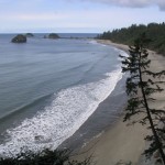
Stretching 70 miles in length and encompassing about 1,400 square miles of intertidal, island, and shoreline habitat, the wild Pacific coast of Olympic National Park is considered to be one of the most complex, diverse and protected shoreline environments in the United States. The U.N. while bestowing World Heritage status referred to ONP as an example of “…superlative natural phenomena. … unmatched in the World.”
WHAT
The Coast is a domain of nature, populated by indigenous plants and animals, where the cycle of elements dictates each day uninterrupted by human influence. The scenery is breathtaking but dangers are also present. High tides and storms must be taken seriously when traveling the beaches.
 Visitors walk, hike and backpack the coast in every season. True to the area’s temperate character summer can be cool and winter can be warmer than elsewhere. Morning fog and gentle rain can be a fellow traveler on any outing, one reason why Gore-Tex® is always in style. On clear days sun protection is a must; there is little shade to be found. Being prepared will increase the joy of exploration.
The Coast’s natural assortment of the unique, the spectacular, and the stunning is perpetually on display. Viewing petroglyphs, tide pools, winter storms, sea stacks, driftwood, headlands, birds, sunsets and in the freshest air on the planet is a short list of what’s to be discovered. There are however strict regulations about harvesting or interfering with marine organisms or defacing anything encountered along the way. The price of admission to this “unmatched” place is respect and responsibility.
WHEN
High tides can, in select places, cover the beach in seawater and bring travel to a temporary halt. The Park Map identifies these places with an orange dot and the advice of the Park’s Wilderness Information Center (WIC) should be sought as part of prudent planning. Headlands are denoted on the Park Map with an orange X because they never have a beach and must always be traversed overland. Again, use caution and consult with the WIC rangers. Extreme tides occur most often in January and June but may occur at other times and can be affected by storms particularly in the fall and early winter.
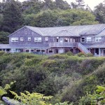 Storms and storm watching from October through February draw visitors who are curious to see firsthand the power of the Pacific. Kalaloch (‘clay-lock’) Lodge is open all year round and is well-suited to storm watchers.
Fall and Winter Storms should always be viewed beyond the reach of the surf which can pitch heavy drift logs about like matchsticks. Pacific storms can create immense ocean waves which often arrive in excess of 8 meters high as they crash ashore. They can be deadly and require prudent respect. Since the 1800s, hundreds of ships have fallen victim to these waters and their rocky shores.
WHERE
The coast is accessible in very few places, listed below:
| Road or Beach Name | GPS Location |
|---|---|
| At its Northern extreme on Makah Nation, from the Hobuck road | N48 17.674 W124 39.906 |
| Moving South, from the Hoko Ozette road | N48 09.209 W124 39.963 |
| Rialto Beach | N47 55.247 W124 38.298 |
| The La Push road Third Beach | N47 53.460 W124 35.963 |
| The La Push road Second Beach | N47 53.892 W 124 37.470 |
| The Oil City road | N47 45.008 W124 25.828 |
| By US 101 from Ruby Beach | 47 45.452 W124 24.837 |
| To South Beach | N47 33.959 W124 21.587 |
To read more about the Olympic Coast, including the history of shipwrecks, click a link below: