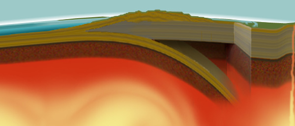
The geological recipe: Take Mountains of lava and add immense areas of seafloor then push, fold, push, fold and repeat this process until the mix runs head-long into the immovable North American continent. Do this continuously over millions of years and the Olympic Peninsula, most noticeably the Olympic Mountains, will be the direct result.
The Juan de Fuca plate, under the sea floor directly west of the Park, The North American plate, the Cascadia Subduction Zone, Accretion wedges, Uplift, and Time are the players in this Olympic adventure. Together they have created within the Park a spectacular array and variety of geologic forms, much of it easily viewed or accessed.
Olympic National Park may well be one of the most accessible displays of this plate collision-uplift process—referred to as orogenic uplift—found anywhere. Other examples in the world include the Himalayas, the Andes and the Alps. But nowhere is this process as active as it is on the Olympic Peninsula. Only the absence of the Park’s huge annual rainfall—as much as 16 feet in some years—and the erosion that it causes keeps Mount Olympus from being the tallest mountain on earth. Geologic studies in the Clearwater River drainage in the southwest portion of the Park have found evidence of the one of the greatest rates of uplift in the world. The following document, published in the April/May 2001 issue of the American Journal of Science provides a detailed examination of uplift and erosion actions in the Clearwater drainage:
Many examples of geology are easily observed in the Park. There is a Geology of the Olympic National Park on the USGS website. It contains interesting information, including links at the bottom of the page. The link titled Geology field trip shows locations of geological interest.
Additionally, the following websites provide much more information on Geology. A visit to them will be worthwhile.
